A raster database of the average height of buildings above the ground (DHM) or average elevation above sea level of buildings and structures (DEM). The data layer is computed using the 3D Building Vector Model.

Technical Specifications
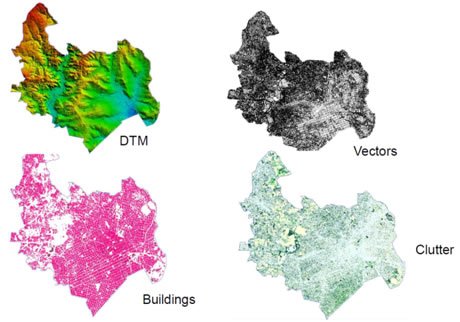
The City is a high-resolution database for use in Radio Frequency Planning in dense urban environments. Data layers provide a detailed simulation environment and include the following layers:
» Raster and Vector 3D Building Model
» Digital Terrain Model
» Clutter
» Linear Vectors
» Ortho-imagery
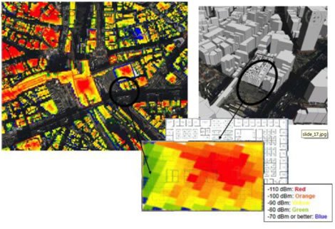
3D building models are a powerful resource for many telecommunication simulation and Modeling
» Ray tracing
» Simulating ‘down-tilt’ angles and antenna positions
» Optimal placement of base stations
» Frequency planning and interference testing
3D Building Model Vector
Planimetric accuracy (x, y) 2m – 3m (RMSE)
Altimetric accuracy (z) 2m – 3m (RMSE)
Minimum Mapping Unit:
„h Minimum building area:
„h Minimum building height: 25 m2 (5m x 5m) 4m
Derivation:
„h Stereo Photogrammetry using Aerial Photography,
QuickBird, WorldView 1 or 2 and/or GeoEye satellite imagery
„h Default height assignment: Max Height
Digital Height Model or Digital Elevation Model
A raster database of the average height of buildings above the ground (DHM) or average elevation above sea level of buildings and structures (DEM). The data layer is computed using the 3D Building Vector Model
The 3D model is derived from high resolution aerial photography, WorldView 1 or 2, GeoEye 1and/or QuickBird satellite imagery (15 – 60cm nominal resolution; maximum cloud cover 0 – 10%). We select the most recent and cost effective sources and specifies these in the commercial offer.
3D building data are delivered in both raster and vector formats. The building vector file represents the building footprint and rooftop structures (x,y) outline and position with an elevation (z) attribute. The building raster is delivered either as a DHM and/or as a DEM, depending on the planning software and/or propagation models being used: Clutter, DSM, ORTHO
1. DHM: Digital Height Model representing only the building heights. Outside the building outlines, the model will have zero or null value.
2. DEM: Digital Elevation Model representing elevations of ground and buildings. (DHM+ Digital Terrain Model)
3D Building Model Raster
» Output Resolution 1m – 5m
» Planimetric Accuracy (x, y) 3m – 5m (RMSE)
» Altimetric Accuracy (z) 2m – 3m (RMSE)
» Minimum Mapping Unit:
» Minimum building area: 25 m² (5m x 5m)o Minimum building height: 4m
Derivation:
» 3D Vector database.
» Default height assignment: Max Height
Clutter Classification
Output Resolution (x,y) 2m – 5m
Planimetric accuracy (x, y) 3m – 5m (RMSE)
Classes (7 minimum):
Open , Bridge, Water Features, Light Vegetation, Sparse Vegetation, Dense Vegetation, Buildings
Classes (15 to 21):
Sea, Inland Water, Wetland, Barren, Grass/Agriculture,
Rangeland,Woodland, Forest, Village,
Suburban, Dense Suburban Low, Dense,
Suburban, Urban, Urban High, Dense Urban, Dense Urban High, Isolated
High Buildings, Building Blocks, Industrial, Airport
» Custom clutter classes available upon request
Derivation:
» Aerial Photography, QuickBird, WorldView 1 or 2 and/or IKONOS
Satellite imagery
» Minimum Map Unit: 5m x 5m
Digital Terrain Model
A raster database of ground surface elevation derived from stereo photogrammetry augmented by contours, stream lines and spot heights from large-scale topographic mapping.
Output Resolution (x,y) 5m
Absolute planimetric accuracy (x,y) 5m – 7m (RMSE)
Absolute altimetric accuracy (z) 5m – 7m (RMSE)
Derivation:
» Stereo Photogrammetry
» 1:5,000-1/10 000 scale topographic mapping
Ortho Imagery
A geometrically corrected 1 meter resolution satellite image.
Linear Vector Features
A vector database of transportation corridors (road width > 5m) and water features derived from satellite imagery and large-scale topographic maps.
Derivation:
The Models are suitable for3G/4G Planning, Micro-cell planning, Vertical positioning of field measurements, Line of Sight (LoS) computation, Diffraction-based algorithms, Empirical, semi-deterministic and ray-tracing models.

2D Linear Vector Features
» Absolute Planimetric Accuracy (x, y) 2m – 3m (RMSE)
» Standard Classes (11):
» Coastline, Double rivers, Single rivers, Inland water, Highways, Main roads, Secondary roads, Railways, Runways, Major streets, Streets.
Derivation:
» Aerial Photography, WorldView 1 or 2, GeoEye-1 and/or QuickBird satellite imagery or
» 1:5,000/1:10 000 scale topographic mapping

Ortho Image
» Output resolution (x,y) 1m
» Absolute planimetric accuracy (x, y) 2m – 3m (RMSE)
Derivation:
» Aerial Photography, WorldView 1 or 2, GeoEye-1 and/or
» QuickBird satellite imagery
» Root Mean Square Error (RMSE) is a statistical measurement of the differences between the
» predicted location of a pixel and the value actually observed expressed in meters.
» No other sources than those used to create the Geodata can be used to challenge clutter accuracy.